Scenic Byways in North Dakota
Search
Recommended Reads


The Spectacular Scenic Byways and Backways of North Dakota
From the Pembina Gorge to the Little Missouri River, North Dakota's scenery is spectacular. Although interstate highways provide the quickest commute, traveling on North Dakota's scenic byways and backways allows travelers an opportunity to see the state's varied scenery up close. As a service, we strive to include information on all byways or backways in North Dakota on our website.
Old Red / Old Ten Scenic Byway
Begins at Mandan Depot on Main Street in Mandan and leads 108 miles west along Old Highway 10 to Dickinson. There is a 12-mile stretch of gravel road near Almont known as the Curlew Loop.

Originally referred to as Old Highway 10, this byway provides ample opportunity to see life as it was many years ago for those who settled in North Dakota. The culture of American Indians to the diverse cultural offerings of the European pioneers are captured along this route. Several regional and local museums are found and a variety of recreational opportunities exist. The natural beauty of the buttes, river valleys and prairie delivers pleasant, rural-life images for the visitor to see. This route is a great alternative to interstate travel with many exits and entrances to/from I-94.
Points of interest:
- Mandan Depot
- Schnell Recreation Area
- Glen Ullin Golf Course
- Dakota Dinosaur Museum
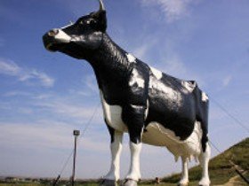
- Salem Sue
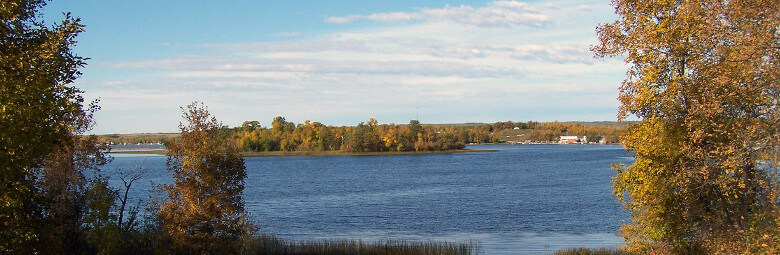
Sakakawea Scenic Byway
Twenty-three miles, Highway 200A from Washburn to Stanton overlooking the majestic Missouri River, through a region filled with history and culture.

This byway highlights some of the state outstanding destinations for visitors seeking information on Lewis and Clark and the Corps of Discovery. Visitors are able to follow the course of the great journey and discover history and culture of the people living on the rolling hills and wooded valleys of the Missouri and Knife rivers.

Points of interest:
- Lewis and Clark Interpretive Center
- Knife River Indian Villages National Historic Site
- Cross Ranch State Park
- Fort Clark State Historic Site
- Fort Mandan Historic Site
Chan SanSan Scenic Backway
Thirty-two miles, heading south from Highway 46 through Adrian, Dickey, Grand Rapids and LaMoure to the intersection of the County Line Road.

The area is rich in Indian history, earthen mounds, early settlement and scenic beauty. Primitive camping is available at Heinrich Martin Dam at Adrian. The Dickey Park has water and sewer hookups with electricity. The Memorial Park at Grand Rapids has hookups with restroom facilities and a shower. LaMoure features dining and motel accommodations.
Points of interest:
- Double pony truss bridge
- Indian burial mounds
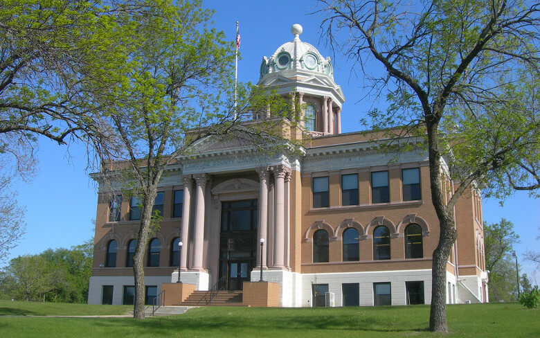
- LaMoure County Courthouse
- Grand Rapids Museum
- Memorial Park musicals
Standing Rock National Native American Scenic Byway
Thirty-five miles, from the Cannonball River south along highway 1806 and 24 to the South Dakota state line.

This national scenic byway conveniently displays rugged terrain along the Missouri River and offers the excitement of cultural and historical discovery. Grand vistas present the Missouri along the same routes traveled by Lewis and Clark, Sakakawea and Sitting Bull. The route offers access to authentic history and culture of Lakota/Dakota people, along with casino entertainment, good food and lodging and uncrowded outdoor recreation.

Points of interest:
- Fort Manuel
- Sitting Bull's Burial Site
- Sitting Bull College Cultural Learning Center
- Standing Rock Monument
- Fort Yates Stockade
Rendezvous Region Scenic Backway
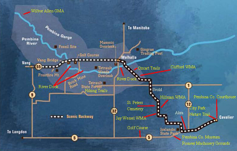
Eleven and one-half miles, from 1 mile east of Walhalla west on Highway 2 and Highway 55 ending at Vang.

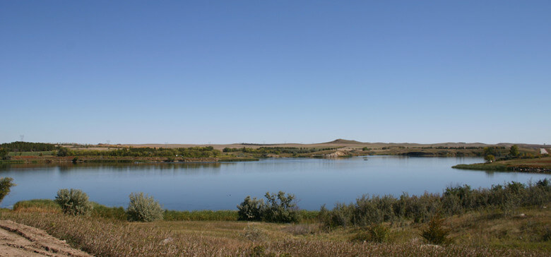
Winding along the bends of the Pembina River, you can enjoy the panorama of the Pembina Gorge and enjoy the recreational, historical and natural scenery opportunities of the area.
Points of interest:
- Scenic Pembina River
- Tetrault Woods State Forest lookout
- Frost Fire Mountain ski lodge
- Active prehistoric fossil dig
- Brick Mine Bridge
Turtle Mountain Scenic Byway
Fifty-three miles, beginning at the intersection of Highway 30 along Rolette County 4006 and Highway 43 to the intersection of Highway 14.
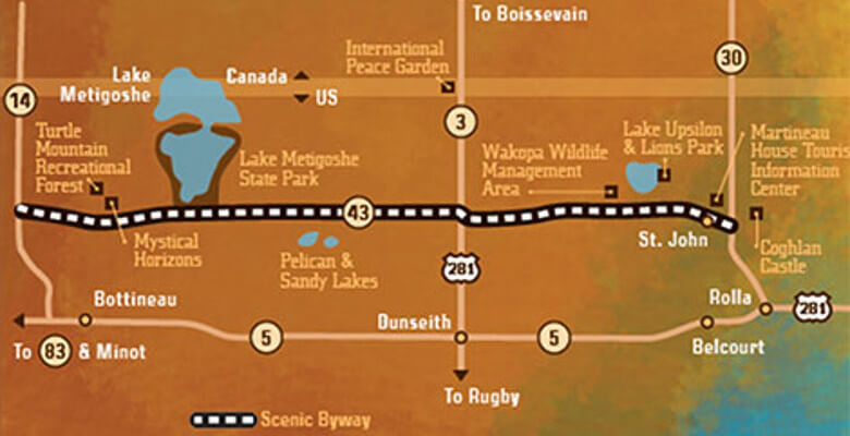
Traveling through the Turtle Mountains, visitors can enjoy beautiful lakes surrounded by pine and aspen, wild flowers and wildlife, and a wide variety of outdoor activities.
Points of interest:
- International Peace Garden
- Lake Upsilon
- Lake Metigoshe State Park
- Martineau House
- Mystical Horizons
Sheyenne River Valley National Scenic Byway
Sixty-three miles, beginning at Getchall Township Hall on Barnes County Highway 21, along Barnes County highways 17 and 19, through Valley City, proceeding on Barnes County Highway 21 to Ransom County Highway 13 Lisbon.

North Dakota's first nationally recognized scenic byway. The tree-speckled valley of the Sheyenne, with a snaking river and winding roadway, is a welcome variation. Quaint towns and farmsteads lend an Americana charm. Come see for yourself!

Points of interest:
- Lake Ashtabula/Bald Hill Dam
- Valley City Historic Bridges Tour/Medicine Wheel Park
- Fort Ransom State Park/Village of Fort Ransom
- Sheyenne State Forest
- Wadeson Park/Walker Dam
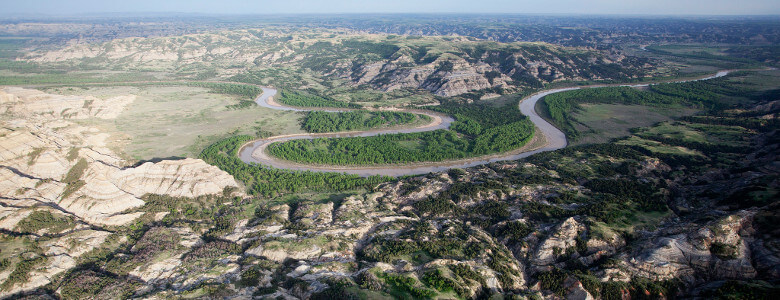
Theodore Roosevelt National Park North Unit Scenic Byway
Fourteen miles, looping through the North Unit of Theodore Roosevelt National Park.

The colorful North Dakota Badlands provide the scenic backdrop to the North Unit's scenic byway. Theodore Roosevelt National Park memorializes the 26th president for his enduring contributions to the conservation of our natural resources. In the park you will find Badlands, open prairie, hardwood draws, bison, other wildlife, the Little Missouri River and a past history that includes Theodore Roosevelt.
Points of interest:
- River Bend Overlook
- Oxbow Overlook
- Bentonite Clay Overlook
- Caprock Coulee Nature Trail
- Cannonball Concretions Pullout
Killdeer Mountain Four Bears Scenic Byway
64 miles, Highway 22 north of Manning to Highway 23, then east to New Town.

The Killdeer Mountains and the deeply entrenched Little Missouri River breaks and Badlands provide a unique and enchanting landscape in one of the most scenic areas of western North Dakota.
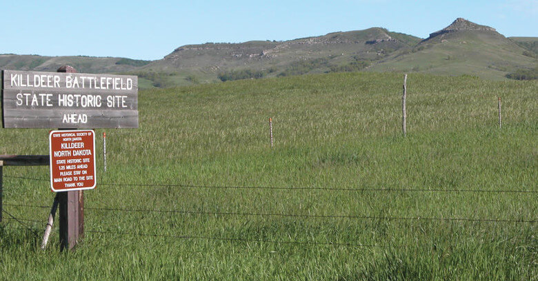
Points of interest:
- Killdeer Mountains
- Killdeer Battlefield Historic Site
- Little Missouri State Park
- Medicine Hole
- Lake Ilo National Wildlife Refuge
Des Lacs National Wildlife Refuge Scenic Backway
Nineteen miles, from Highway 52, 6 miles south of Kenmare to Ward County Road 1.
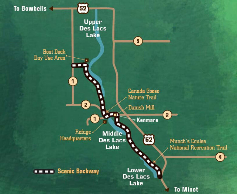
This backway provides an excellent opportunity to view and photograph waterfowl, water and songbirds, raptors, deer, wild turkeys and other wildlife. From the marshes, woodlands and lakes to the upland prairie, travel through a great host of natural habitat and scenery.

Points of interest:
- Five species of nesting Grebes
- Hiking trails and interpretive sites along backway route
- Large concentration of migratory waterfowl with up to 300,000 snow geese
- Contemporary historic sites along the route
- One-of-a-kind historic Danish Mill located in Kenmare